Ramanathaswamy Temple
Location in Tamil Nadu
Name
Proper name Ramanathaswamy Thirukoil
Geography
Coordinates 9.288106°N 79.317282°ECoordinates: 9.288106°N 79.317282°E
Country India India
State Tamil Nadu
District Ramanathapuram
Location Rameswaram
Culture
Primary deity Ramanathaswamy (Shiva)
Architecture
Architectural styles Dravidian architecture
History and governance
Creator Pandya and Jaffna kings
For more details visit official Temple Website
Arulmigu Ramanatha Swamy Temple - History

History :
The temple and the island of Rameswaram have acquired this name because, Lord Rama worshipped Lord Shiva, the God of Gods here on return from Sri Lanka. According to legend, after killing Ravana Lord Rama returned with his consort Goddess Seetha to India first stepping on the shores of Rameswaram. To expiate the "dosha" of killing a brahmin, Lord Rama wanted to offer worship to Lord Shiva. Since there was no shrine in the island had despatched Sri Hauman to Kailash to bring an idol of Lord Shiva.
Between 1897 and 1904, the ALAR family of Devakottai completed the imposing eastern tower of nine tiers 126 feet in height from Thiruppani funds. Between 1907 and 1925 they renovated the Sanctum Sanctorum and the prakaram(inner most corridor) by replacing the lime stones by black granite with adequate provision for light and ventilation and also arranged for the performance of Ashtabandana Kumbabishekam in 1925; then on 22-2-1947 and the third Ashtabandana Maha Kumbabishegam was performed on 5-2-1975.
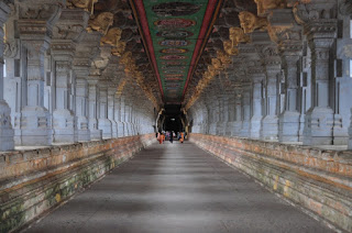
World Famous Third Corridor :
Outer Wing - East_West – 690 feet
North-South - 435 feet
Innerwing - East_West - 649 feet
North-South - 395 feet
Total number of pillars – 1212
Height of Corridor – 22 feet 7 ½ inch
For more details visit official Temple Website
Second Corridor :
During the construction of first corridor, it was decided to renovate the second corridor. The lime stone structure in Second corridor was dismantled and started granited stone work. But only compound wall in west side and one portion in north side of western wing in south gate was renovate. After that no Renovation work as done.


Therefore, it was proposed to complete the Renovation work of Second Corridor by collecting Funds from the public. Between 1961 to 1985, the Renovation work of Second Corridor was taken up and completed the western side of Second Corridor and a portion in North and South side, from the Temple Renovation Fund. Now it has been proposed to complete the Renovation of Second Corridor which has been unfinished and the Renovation work is started now.
For more details visit official Temple Website
The Sethupathy mandapam in front of the Temple’s Raja Gopuram9main Tower) was constructed by Ramanatha Sethupathy, a descendant of Ramnad Raja dynasty, with his own donation of Rs. 2,75,000 /-. This construction was started on 19-11-69 and completed on 11-2-74.
It is also most essential to construct the North and South Gopurams. Shri Jagadguru Sringeri Peedathipathy and Shri jagadguru Kanchi Kamakoti Peedathipathy have given their kind blessings for the constructions of the North and South Gopurams of the Temple.
For more details visit official Temple Website
Rameswaram bridge
The Pamban Bridge is a railway bridge on the Palk Strait which connects the town of Rameswaram on Pamban Island to mainland India. The bridge refers to both the road bridge and the cantilever railway bridge, though primarily it means the latter. Opened on 24 February 1914, it was India's first sea bridge, and was the longest sea bridge in India until the opening of the Bandra-Worli Sea Link in 2010. The rail bridge is for the most part, a conventional bridge resting on concrete piers, but has a double leaf bascule section midway, which can be raised to let ships and barges pass through.


Location in Tamil Nadu
Name
Proper name Ramanathaswamy Thirukoil
Geography
Coordinates 9.288106°N 79.317282°ECoordinates: 9.288106°N 79.317282°E
Country India India
State Tamil Nadu
District Ramanathapuram
Location Rameswaram
Culture
Primary deity Ramanathaswamy (Shiva)
Architecture
Architectural styles Dravidian architecture
History and governance
Creator Pandya and Jaffna kings
For more details visit official Temple Website
Arulmigu Ramanatha Swamy Temple - History

History :
The temple and the island of Rameswaram have acquired this name because, Lord Rama worshipped Lord Shiva, the God of Gods here on return from Sri Lanka. According to legend, after killing Ravana Lord Rama returned with his consort Goddess Seetha to India first stepping on the shores of Rameswaram. To expiate the "dosha" of killing a brahmin, Lord Rama wanted to offer worship to Lord Shiva. Since there was no shrine in the island had despatched Sri Hauman to Kailash to bring an idol of Lord Shiva.
Between 1897 and 1904, the ALAR family of Devakottai completed the imposing eastern tower of nine tiers 126 feet in height from Thiruppani funds. Between 1907 and 1925 they renovated the Sanctum Sanctorum and the prakaram(inner most corridor) by replacing the lime stones by black granite with adequate provision for light and ventilation and also arranged for the performance of Ashtabandana Kumbabishekam in 1925; then on 22-2-1947 and the third Ashtabandana Maha Kumbabishegam was performed on 5-2-1975.
World Famous Third Corridor :
Outer Wing - East_West – 690 feet
North-South - 435 feet
Innerwing - East_West - 649 feet
North-South - 395 feet
Total number of pillars – 1212
Height of Corridor – 22 feet 7 ½ inch
For more details visit official Temple Website
During the construction of first corridor, it was decided to renovate the second corridor. The lime stone structure in Second corridor was dismantled and started granited stone work. But only compound wall in west side and one portion in north side of western wing in south gate was renovate. After that no Renovation work as done.


Therefore, it was proposed to complete the Renovation work of Second Corridor by collecting Funds from the public. Between 1961 to 1985, the Renovation work of Second Corridor was taken up and completed the western side of Second Corridor and a portion in North and South side, from the Temple Renovation Fund. Now it has been proposed to complete the Renovation of Second Corridor which has been unfinished and the Renovation work is started now.
For more details visit official Temple Website
It is also most essential to construct the North and South Gopurams. Shri Jagadguru Sringeri Peedathipathy and Shri jagadguru Kanchi Kamakoti Peedathipathy have given their kind blessings for the constructions of the North and South Gopurams of the Temple.
For more details visit official Temple Website
Rameswaram bridge
The Pamban Bridge is a railway bridge on the Palk Strait which connects the town of Rameswaram on Pamban Island to mainland India. The bridge refers to both the road bridge and the cantilever railway bridge, though primarily it means the latter. Opened on 24 February 1914, it was India's first sea bridge, and was the longest sea bridge in India until the opening of the Bandra-Worli Sea Link in 2010. The rail bridge is for the most part, a conventional bridge resting on concrete piers, but has a double leaf bascule section midway, which can be raised to let ships and barges pass through.


The railway bridge is 6,776 ft (2,065 m) long.[1] It was opened on 24 February 1914, construction having begun in 1911. However plans for a bridge had been suggested from as early as 1870 as the British Administration sought ways to increase trade with Ceylon.[2] The bridge has a still-functioning double-leaf bascule section that can be raised to let ships pass.
The adjacent road bridge was opened in 1988.[2]
The railway bridge historically carried metre gauge trains, but Indian Railways upgraded the bridge to carry broad gauge trains as part of Project Unigauge,[2] work that was completed on 12 August 2007.[citation needed] Until recently, the two leaves of the bridge were opened manually using levers by workers.[1] Around 10 ships — cargo carriers, coast guard ships, fishing vessels and oil tankers — pass through the bridge every month.[2] More work was carried out on the bridge in 2009 to strengthen it to enable it to carry goods trains.[2]
Pamban Bridge, Rameshwaram
Pamban Bridge
Inaugural plaque
After completion of the bridge, metre-gauge lines were laid from Mandapam up to Pamban station. From here the railway line bifurcated, one line towards Rameshwaram about 6.25 miles (10.06 km) up and another branch line of 15 miles (24 km) terminating at Dhanushkodi. The section was opened to traffic in 1914.[3][4] The Ministry of Indian Railways sanctioned Rs. 25 crore to replace the existing 65.23-meter- long rolling type span, which opened like a pair of scissors to allow the vessels to pass the bridge with 66-meter-long single truss span which could be opened with the press of the button.[5]
The noted Boat Mail ran on this track between 1915 and 1964 from Madras-Egmore up to Dhanushkodi, from where the passengers were ferried to Talaimannar in Ceylon. The metre-gauge branch line from Pamban Junction to Dhanushkodi was abandoned after it was destroyed by the 1964 Dhanushkodi cyclone.[6]
Pamban Bridge, Rameshwaram
Rail Bridge from Indian mainland to Rameshwaram
The bridge was subsequently restored to working conditions under Elattuvalapil Sreedharan in just 46 days.[7] On 13 January 2013 the bridge suffered minor damage when a naval barge drifted into it. The tug towing a naval barge from Kolkata to Karwar near Mumbai ran aground hitting rocks on 10 January during bad weather. The 220 tonne barge then drifted into the bridge causing part of it to tilt slightly and requiring repair work to the piers.[8] In 2013 it was reported that Indian Railways had applied to UNESCO for the bridge to be made a world heritage site
No comments:
Post a Comment